Posts

Final Hazards Report - Turkey

Image
Final Hazards Report - Turkey After a semester of research on the hazards of Turkey, the two main hazards I will be discussing in this final blog is mass wasting and earthquakes.  Scientists have found nearly 45 active slides alone on Mount Akdag, along the Western Taurus range in Turkey. Mass wasting, or landslides, is the movement of earth materials downslope and, although perhaps not as dramatic as an earthquake or a volcano, the results, nevertheless, can be as devastating. Karst, glacial, tectonic and gravitational processes which contribute to mass wasting exist more than a mile high on Mount Akdag.  The southern slope is the most active, with a slide covering more than three miles, and with a total spread of just over six miles. However, this mountain has a preponderance of landslides which have occurred all around it. High debris which flows down into the river system at the base of the mountain contributes to frequent torrents and flooding and presents

Rising Seas in Turkey

Image
Turkey's coastal provinces make up roughly 30% of the country's entire land.  And, about 30 million residents, out of a total population of 75.6 million, live along the coast.  More people than ever are moving to the world's coasts, increasing the pressure to relax development standards created for safety, such as building too close to the shore.   Turkey’s Intergovernmental Panel on Climate Change's (IPCC) Fourth Assessment Report (May 2018) estimates that the global sea level will rise an estimated 7 to 23 inches in the next century due to global climate change, global warming and melting of ice sheets. Rising sea levels will result, inundating wetlands and other low-lying lands, eroding beaches, intensify flooding, and increasing salinity of rivers and groundwater tables.  With so much of the country at risk of flooding due to rising sea levels,Turkey is on it!  Sea level observation stations (tide gauges) in Turkey are deployed and operated for mapping act

Turkey Reduces Wildfire Losses by 80%

Image
Like much of the rest of the world subjected to a changing environment and rapid urbanization, wildfires have been steadily increasing.   For example, m ore than 620,000 acres of forest land burned in 1,132 fires during 2017 alone when forest lands were turned into ashes because of different fires which occurred in the western province of İzmir. Both human and wildlife lives were lost and local forestry ministers estimate it will take 10 years or more for a new ecosystem and forest to form. Fires also burned in Turkey in the Mediterranean and Aegean provinces of Muğla, Antalya and Denizli in 2017, as well as the eastern province of Erzurum and the capital of Ankara.   This satellite image was collected by the Moderate Resolution Imaging Spectroradiometer (MODIS) on the NASA Aqua satellite on July 3, 2017.   Actively burning areas, detected by MODIS’s thermal bands appear in red. According to the 2016 statistics, only 10 percent of the forest land fires were caused by

Coastal Erosion in Turkey

Image
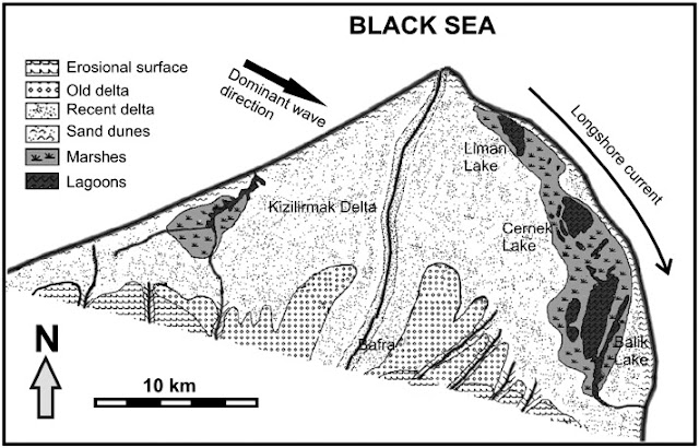
   In the northeast of Turkey, the Eastern Black Sea Region has been exposed to severe    coastal erosion and shoreline recession for the last 30 years.  Manmade activities are one of the most critical reasons for this problem.   This coastal imbalance was due to commercial and municipal sand mining. Another cause which contributed to this coastal imbalance was the construction of a highway near the shore. This project used fill soil close to the coast. Wave energy increases by reflected waves along these slopes and causes a littoral sediment transport. Finally, the other important reason for erosion and recession is also manmade, pertaining to incorrect site selection and planning and design of coastal structures such as harbors and fishery harbors, for example. Possible remedies to re-establish beaches are being investigated and some design criteria changes have been presented to change various engineering structures to fortify these coastal areas such that they are

Cyclone Appears in Turkey for First Time, Batters Istanbul

Image
First recorded hurricane (cyclone) in memory occurred in Turkey April 18, 2012 For the first time in recorded memory, a cyclone on April 18, 2012, hit Turkey, with strong winds battering Istanbul, closing the bridge over the Bosporus and wreaking havoc in the Grand Bazaar.    Turkish hydro-meteorology  specialists reported that the wind speeds, at the onset of the storm, reached nearly 50 MPH.  T he State Meteorological Bureau warned that winds with speeds of up to 62 miles per hour were expected. Scientists agree that this is the first time that Turkey witness ed   a hurricane -like   storm .  Residents living in the cities of İzmir and İstanbul who have lived their whole life in those cities, say they have never seen such a storm as this one.  Six persons are reported to have died in this storm.     Another powerful hurricane hit Istanbul on July 29, 2017.   Flooding was so deep that people had to swim across the streets.   Rescue operati

Extreme Weather in Turkey

Image
  Giant hailstones and torrential downpours leave the streets of Istanbul under water. “Severe weather refers to events such as thunderstorms, tornadoes, hurricanes, blizzards, ice storms, mountain windstorms, heat waves and dust storms…and are considered hazardous because of the energy they release and damage they are capable of causing,” according to Keller and De Vecchio in their textbook, Natural Hazards . Here is an interesting news segment of scientists talking about recent incidents of severe weather in the U.S., and whether those are the result of extreme weather or climate change.   Although the length (24 minutes) is somewhat long, the interviews with a cadre of scientists from highly regarded scientific institutions throughout the U.S., along with insurance industry experts, as they strive to create extreme weather events in a huge lab, make for fascinating viewing: https://www.aljazeera.com/programmes/techknow/2015/12/extreme-weather-coincidence-climate-cha