Final Hazards Report - Turkey
Final Hazards Report - Turkey
After a semester of research on the hazards of Turkey, the two main hazards I will be discussing in this final blog is mass wasting and earthquakes.

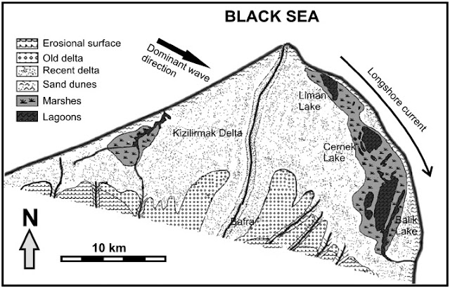
Scientists have found nearly 45 active slides alone on Mount Akdag, along the Western Taurus range in Turkey. Mass wasting, or landslides, is the movement of earth materials downslope and, although perhaps not as dramatic as an earthquake or a volcano, the results, nevertheless, can be as devastating. Karst, glacial, tectonic and gravitational processes which contribute to mass wasting exist more than a mile high on Mount Akdag.
Scientists have developed a geomorphological map of the slide using Geographic Information Systems (GIS), to better understand the sedimentary dynamics and help reduce hazards there in the future. Additionally, there is an early warning system, both by observation and with electronic gauges which monitor movement of the earth.

Earthquake survivors
look at a collapsed building in Istanbul in August 1999. The magnitude 7.4
quake killed 17,000 people across northwestern Turkey.
Recent earthquakes
in Turkey:
September
6, 1975 -
An earthquake devastates the town of Lice and surrounding villages. It measures
6.7. At least 2,350 people are killed and 3,000 injured.
November
24, 1976
- A quake of 7.3 magnitude hits Van Province, killing 5,291. The town of
Muradiye and hundreds of villages are destroyed.
October
30, 1983
- About 1,340 people are killed and 530 injured when an earthquake hits the
Turkish city of Erzurum in the northeast. Measuring 6.9, 50 villages are
destroyed in the provinces of Erzurum and Kars.
August 17, 1999 - A quake measuring 7.6
strikes the western Turkish city of Izmit, 90 km southeast of Istanbul, killing
at least 17,118 people with nearly 50,000 injured, about 500,000 people homeless
and an estimated $3-6.5 billion in damage in Istanbul, Kocaeli and Sakarya
Provinces.
Oct
23, 2011
- A 7.2 magnitude quake strikes the city of Van and town of Ercis, some 100 km
to the north, killing at least 523 people with hundreds more missing. Turkey’s
biggest quake in more than a decade also injured 1,650 people.
After these devastating earthquakes, recommendations were made
to address hazards.
Buildings were slated for strengthening and new construction
standards were set. Central to the emergency plan was the designation of
hundreds of urban green spaces as evacuation points, where people could escape
collapsing buildings and other debris in the event of another large earthquake.
But nearly 20 years later, many of those evacuation zones have vanished.

Four high rises loom over an
Istanbul park. The land they sit on was designated as an evacuation zone after
the 1999 quake but was later sold to developers. Some Turkish officials have gone further,
identifying corruption as a big part of the problem.
Despite the past, Turkish officials
insists it is now working to improve Turkey's earthquake preparedness. But
neither the deputy prime minister's office in charge of preparedness, nor
Turkey's official aid groups responded to several requests for comment for this
story.
Meanwhile, an architect’s union says some
7 million buildings in Turkey are still unsafe, 2 million of them in Istanbul.
And scientists say that another large earthquake is likely in Turkey's
future. If it happens, people will need someplace safe to go.
Turkey has suffered from
some of the worst earthquakes in the world.
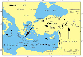
Istanbul, with its more than 18 million people is the most vulnerable to earthquakes, sitting near the convergence of three tectonic plates: the Anatolian Plate, the Eurasian Plate and North African Plate. Mt. Akdag, located above a major tourist site in Turkey, is the most vulnerable to mass wasting.
Istanbul, with its more than 18 million people is the most vulnerable to earthquakes, sitting near the convergence of three tectonic plates: the Anatolian Plate, the Eurasian Plate and North African Plate. Mt. Akdag, located above a major tourist site in Turkey, is the most vulnerable to mass wasting.

“With an estimated seven million dwellings in
the country, including two million in Istanbul, deemed“ unsafe,” according to the
Istanbul office of the Union of Architects and Engineers of Turkey (TMMOB), “there
is much work to be done.”
The statement was issued on the 18th anniversary of the 1999 Marmara earthquake, the worst seismic disaster in Turkey’s recent history which killed over 17,000 people.
The group also warned that many areas previously assigned as earthquake assembly areas in Istanbul were now being used for other purposes. In March, the TMMOB revealed that 300 out of 470 such assembly areas were being used as shopping malls and business centers.

The adjacent map details
peak ground acceleration over the past 50 years in the Mediterranean. Without
going too deep into science, peak ground acceleration is essentially the
measurement of how hard the earth shakes in a given area. When you look at the
map, you can easily see that some of the darkest red patches are Turkey. As on
most maps, red usually doesn’t equal anything good!
Where would you construct your house in Turkey
to avoid these hazards?
If you look at the map
above, the yellow spot to the south, directly across from Cyprus, signifies historically
fewer earthquakes than most anywhere else in Turkey. This is the area between
Anamur and Silike.
If I was to build a
home in Turkey, I would choose Anamur, a town and district of the province of
Mersin, on the Mediterranean coast of southern Turkey, between Antalya and the
city of Mersin, an area known as the Turquoise Coast.. Anamur is Anatolia's
southernmost point, a coastal resort famous for its bananas and peanuts. It is somewhat rustic compared to the sophistication
of Istanbul and other metropolitan areas in Turkey; however, that also makes it
more affordable.
Here are some photos I
found, which look very inviting.


However, although it may be
coded “yellow,” as safer with regard to earthquakes, there are other dangers, as well. It is quite close to the war
at the Syrian border and where the refugees may be coming across. Further, the travel advisories recommend
against women alone traveling in Turkey, even to the markets. Therefore, as beautiful as spot as this is, I
think I’ll stay home!
REFERENCES

Great and compete final report for Turkey! (thank you the images too) I agree with your chosen hazards and your mitigation measures. I hope you enjoyed your research with us!
ReplyDelete