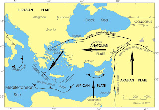
Posts

Showing posts from February, 2018

Volcanoes in Turkey

Image
How do Volcanoes Work?    Before we begin discussing volcanoes, here is a short video clip with Dr. Liz Cottrell, of the Smithsonian Institution's National Museum of Natural History.  She talks about what causes a volcano to erupt and demonstrates the principle behind the eruption:  https://www.youtube.com/watch?v=6BGd79g1tms Turkey: Rich in Volcanoes Turkey ranked 14th, in an assessment of overall volcanic threat, out of 95 volcanically active countries, reflecting high population exposure.   T urkey is vulnerable to volcanic hazards due to the large exposed population, lack of experience of public officials and communities with volcanic emergencies, very limited volcano monitoring, and lack of knowledge on volcanic hazards and risk.  Examples of different types of volcanoes in Turkey Mt. Ararat – Stratovolcano Last eruption – 1840 CE The 5165-m-high, double-peaked stratovolcano Mount Ararat, also known as Agri Dagi, is Turkey's highest, largest

Tsunamis affecting Turkey

Image
According to  Ready.gov, , tsunamis are caused by "seismic sea waves." These are not the same as "tidal waves."   Tsunamis are created by underwater disturbances, such as earthquakes, landslides, volcanic eruption, or meteorites.  Earthquakes, though, remain the predominant cause of tsunamis in this region. About 10% of tsunamis worldwide occur in this Mediterranean region. Approximately one disastrous tsunami has taken place in this region  each century. In Turkey, tsunamis occur when  earthquakes, primarily caused by the African Plate drifting north, are subducting underneath the Eurasian Plate, in the Mediterranean Sea, or in other waters surrounding Europe. There have been three such occurrences which have been classified as  tsunamis, since  the year 365 A,D. (See dark blue "wave" symbols on map, above.)  It is estimated that a total of 155 people have been killed in Turkey due to tsunamis.  However, tsunamis are rare in this region.. 

Turkey: Where a Major Earthquake is Overdue

Image
                                       This diagram shows the Marmara Sea region in northwestern Turkey.  This is where the North Anatolian Fault Zone (NAFZ) separates the Eurasian plate from the Anatolian plate.  The red line indicates where a major earthquake is overdue. This is offshore on the Marmara fault.  The black lines on either side of the red area are where the last two major ruptures on this fault took place.  These were the Ganos quake in 1912 (on the left) and the Izmit quake in 1999 (on the right). Yellow stars in the center of the diagram designate repeating earthquakes and, according to a recently published study, the green rectangle surrounding the yellow stars, indicates fault creep, while the blue rectangle, (located just off center to the right in the diagram) indicates the fault portion which lies just offshore, near Istanbul. This section is locked. There has not been a major earthquake on the Marmara section since 1766; however, based on histori

Tectonic Plates and Fault Zones of Turkey

Image
Tectonic Plate Map of Turkey Turkey is is vulnerable to many natural hazards.  The country's primary natural hazards are earthquakes, landslides and floods.   Turkey is bordered on the north by the North Anatolian Fault Zone (NAFZ), which forms the boundary between the Anatolian plate,  and the Eurasian plate to its north.  The Anatolian Plate encompasses the entire country of Turkey, stretching eastward across the country for  nearly 750 miles (900 km).   The NAFZ is a continental transform fault .  This fault interlocks with the Eurasian fault as it moves to the west.   Turkey is bounded on the east by the East Anatolian Fault Zone (EAFZ), which separates the Anatolian plate from the Arabian plate, on the border between Turkey and Syria. This area, according to N. Turkelli, et al, in Seismic Zones in Eastern Turkey,   "... is one of the youngest continent-continent collision zones on earth , where the Arabian plate collides with the Eurasian plate