Turkey: Where a Major Earthquake is Overdue

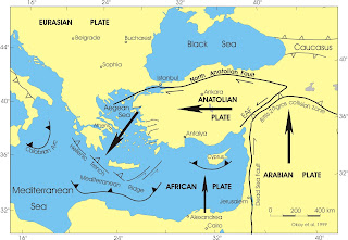
This diagram shows the Marmara Sea region in northwestern
Turkey. This is where the North
Anatolian Fault Zone (NAFZ) separates the Eurasian plate from the Anatolian
plate. The red line indicates where a
major earthquake is overdue. This is offshore on the Marmara fault. The black
lines on either side of the red area are where the last two major ruptures on
this fault took place. These were the
Ganos quake in 1912 (on the left) and the Izmit quake in 1999 (on the right).
Yellow stars in the center of the diagram designate
repeating earthquakes and, according to a recently published study, the green rectangle
surrounding the yellow stars, indicates fault creep, while the blue rectangle, (located
just off center to the right in the diagram) indicates the fault portion which
lies just offshore, near Istanbul. This
section is locked.
There has not been a major earthquake on the Marmara section
since 1766; however, based on historical records, it is known to rupture
approximately every 250 years.
Of great concern with this location, is the proximity of Istanbul,
a metropolitan area of more than 15 million people, to this seismically sensitive area. Here, below the surface, energy builds up,
similar to a rubber band which has been stretched, almost to its limit. This results in the interlocking of tectonic
plates, (this is a transform fault), which causes the fault to get hung up and
come to a halt, until the “rubber band” snaps and an earthquake releases this
built-up energy.
Scientists fully expect that a major earthquake of M7, or
greater, will occur in this area in the near future.
According to scientist Marco Bohnhoff, in a recent article in Geophysical
Journal International, "This is
both good news and bad news for this city with over 15 million inhabitants. The
good news: "The rupture propagation will then run eastwards; i.e., away
from the city," explains the researcher. "The bad news is that there
will only be a very short early warning phase of a few seconds." According to Bohnhoff and his team, “Early
warning times are extremely important in order to switch traffic lights to red,
to block tunnels and bridges or to shut down critical infrastructure.”
With respect to
its geological and geomorphological structure, Turkey is at risk for many
natural disasters, such as earthquakes, floods, landslides. Most
significant of all, is that areas having major population centers are co-located along
major fault lines.
REFERENCES
Marco
Bohnhoff, Christopher Wollin, et al., Repeating Marmara Sea Earthquakes:
Indication for fault creep. Geophysical Journal International,
2017; DOI
GFZ GeoForschungsZentrum
Potsdam, Helmholtz Centre. "From
where will the next big earthquake hit the city of Istanbul? Researchers
estimate that it will happen in the East of the metropole."
ScienceDaily, 16 May 2017.
Muharrem Aydun, Natural
Disasters in Turkey and Natural Disaster Profile of Bursa. Bursa Orhangazi
University, Turkey. arcjournals.org.
Edward A. Keller & Duane
E. DeVecchio, Natural Hazards: Earth’s
Processes as Hazards, Disasters, and Catastrophes. 2015.

Comments
Post a Comment