Turkey at Risk for Mass Wasting & Landslides
 Mass wasting is a term used for
any type of downslope movement of earth materials, such as rocks or soil. Most of you are probably more familiar with
the term “landslide.”
Mass wasting is a term used for
any type of downslope movement of earth materials, such as rocks or soil. Most of you are probably more familiar with
the term “landslide.”In Turkey, on Mount Akdag, for example, scientists have found “43 highly developed and active mass movements.” Mount Akdag is in the Western Taurus range in Turkey.
Photo: Mount Akdag
Researchers state that climate changes have also had an important impact on these polygenetic topographies. Glaciers have helped form the geomorphological evolution of Mount Akdag, which is considered quite complex.
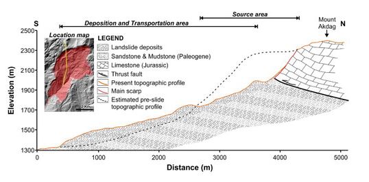
The region is highly active in terms of sedimentary dynamics and geomorphological processes are generally dominated by mass movements. Landslides have occurred all around the mountainside, but this activity is especially observed on the southern slope. The landslide that developed on the southern slope is possibly the largest landslide of its type in the Taurus Range.
This landslide alone resulted in the collapse of a 3.1 mile segment of Mount Akdag and today covers an area a little over 6 miles. This particular landslide presents significant challenges to geohazard management in the region. More and more geohazard events are occurring in this area, due to the high debris which flows downhill into the river system, at the base of this landslide during the frequent and fatal torrents observed in the region.
In past years, there have been numerous catastrophic rainstorms in the Saklikent Canyon, which is a tourist site located downstream. Therefore, slope failures and torrent hazards pose a serious risk to tourists and the local population. In this respect, long-term monitoring of the landslide’s activity and the quantity and transfer of sediment are necessary.
Scientists are compiling a detailed geomorphological map of the landslide, to gain a better understanding of the sedimentary dynamics and landscape evolution of the region through mapping the multiple widespread mass movements and to also reduce possible future hazards in this area. Additionally, researchers have been preparing an integrated mass wasting susceptibility assessment using geographical information systems (GIS) and remote sensing applications. Of course, the best and safest course of prevention would be to curtail development in this area and to change land use policies to reflect a "no build" greenbelt in the areas that are the most unstable.
REFERENCES
, , & (2011).
Mineral Research & Exploration General Directorate Special Publication
Series-27, Ankara, Turkey. p. 1.
Edward A. Keller & Duane E. DeVecchio, Natural Hazards: Earth’s Processes as
Hazards, Disasters, and Catastrophes. 2015.


GIS is widely used these days for risk mapping....it is good to see they are aware and prepared somewhat for these hazards...
ReplyDeleteYes, I agree. GIS is a valuable tool to evaluate future risk.
ReplyDelete